Non-threaded

Forums » The Lounge » Read Thread

A place to sit back, hang out, and make monkey noises about anything you'd like.

The CYS Weather Thread!! (2023 Edition)

8 months ago

Since we’re approaching peak hurricane season and winter is only a couple months away, I figured I would start a thread devoted to all of my nerdy weather reports!

Now those who are a part of the “When I see it I’ll believe it” club will know what thread to ignore! (Plus I won’t keep bumping mizals poor neglected world news thread)

The CYS Weather Thread!! (2023 Edition)

8 months ago
Commended by mizal on 8/25/2023 8:13:12 PM

8/19 

August Heat Wave 

Remember when I kept warning about the heat our El Niño was going to inevitable bring this summer awhile back? Well it’s finally here and it is going to be really hot.

IMG_2191.jpeg

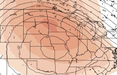
Currently a highly anomalous high pressure system is beginning to build over the central plains. As this ridge strengthens it will go on to produce some of the hottest temperatures recorded this summer. This heat will likely stick around all of next week before a cold front potentially provides some much needed relief next weekend.

IMG_2190.jpeg

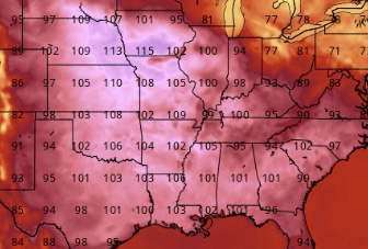
It is likely many record highs will fall across the central United States next week.

Hurricane Hilary (What an ironic name)

I’m sure everyone and their mother has heard about how historic this storm is going to be and unfortunately all of those hyped up news articles are very true (First tropical system to affect California since 1939 and the first ever system to prompt tropical storm watches/now warnings).

IMG_2195.jpeg

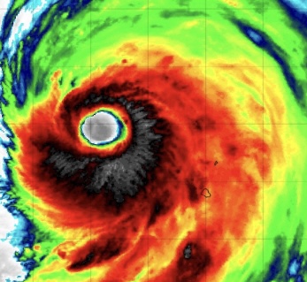
After strengthening to a mid range Cat 4 yesterday Hilary has weakened to a still impressive 130 MPH hurricane as it begins to race north.
IMG_2196.jpeg

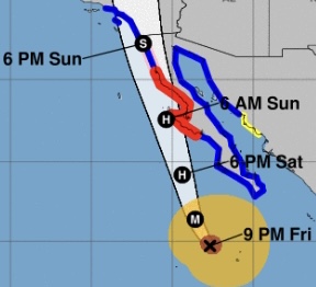
Today Hilary will begin to speed up as the ridge over the central plains pulls it north. While the storm advances north it will also begin to weaken as sea surface temperatures cool and wind shear increases. However, this weakening trend will allow the storm to grow in size as well so by the time it approaches the Baja peninsula Hilary will be a very large hurricane. The expected immense size of this storm is the main reason the NHC has issued tropical storm warnings for Southern California.
IMG_2197.jpeg

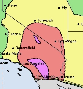
By the time Hilary reaches California it will have weakened to a tropical storm but will still be very capable of producing gusty winds and most damaging of all, heavy rainfall. Widespread rainfall on this scale is very very rarely seen in Southern California during the summer months which is why the flash flood risk is so high for the area. Anyone living near bodies of water in Southern California should be making preparations to protect property and if possible move to higher ground before the storm arrives.

The Atlantic is Waking Up

For the past 2 almost 3 months a combination of high wind shear and dry air has kept tropical activity in the Atlantic basin relatively quiet. Unfortunately as we approach peak hurricane season, wind shear across the basin is weakening and the dry air which has been so prevalent across the main development region, is beginning to dissipate.

IMG_2194.jpeg

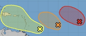
These disappearing negative factors for tropical development are why there are currently 4 AOI’s (Areas of interest) in the Atlantic. 3 of these AOI’s are beginning to spin off of the African coastline, luckily all of these tropical waves should develop and fizzle out safely at sea (Though they will likely still produce a rip current risk along some select coastlines). 
IMG_2198.jpeg

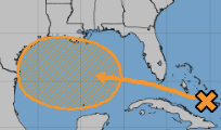
The 4th AOI is currently located over the Bahamas and is expected to potentially develop into a tropical system later next week (50% chance). If it does develop this AOI should stay relatively weak due to still present wind shear over the northern gulf but it will likely still produce heavy rainfall and gusty winds for some portions of Texas and Mexico.

The CYS Weather Thread!! (2023 Edition)

8 months ago

I hope that the waffle house will still be open

The CYS Weather Thread!! (2023 Edition)

8 months ago

This is great, Aldreda.

The CYS Weather Thread!! (2023 Edition)

7 months ago
It was not particularly hot here. In fact, it was very mild much of the summer. You're lying.

The CYS Weather Thread!! (2023 Edition)

8 months ago

8/25

Invest 93L

Invest 93L has formed in the western Caribbean and currently has a high (80%) chance of becoming a tropical system per the latest NHC update. The storm is currently expected to move into the Gulf of Mexico next week and pose a threat to Florida.

Screenshot 2023-08-25 190849.png

The environment ahead of 93L will be quite conductive for strengthening (Low wind shear, ample moisture and really hot waters). The one thing that should prevent this system from becoming a monster is its fast speed through the gulf.

Screenshot 2023-08-25 190136.png

By the time 93L approaches the Florida coastline sometime Wednesday it will have likely strengthened to a low-end hurricane (Intensity will depend on how fast it organizes). Right now, it is looking likely landfall will occur somewhere in the big bend area.

Screenshot 2023-08-25 192017.png

The CYS Weather Thread!! (2023 Edition)

8 months ago
If at any point the Gulf Coast gets hit by a hurricane this thread didn't warn me about, I am going to ban you as soon as I have power again.

The CYS Weather Thread!! (2023 Edition)

8 months ago

Yay! I have a job!

The CYS Weather Thread!! (2023 Edition)

8 months ago

8/27

Tropical Depression 10

TD10 (Formerly 93L) formed near the Yucatan peninsula earlier today. Assuming the systems center doesn’t move onshore it will likely become tropical storm Idalia during DMAX (Diurnal Maximum) tonight. 
IMG_2231.jpeg

Future Idalia will meander around a bit today before finally getting pulled north by an approaching shortwave trough. During this initial journey north across the southern gulf, moderate wind shear from a nearby ULL (Upper level low) will restrict thunderstorm growth on the western side of the system which will slow intensification. 
IMG_2226.jpeg

However by Tuesday the systems orientation to an approaching trough in the Midwest and the ULL over Texas may lead to the shear helping the storm instead of hurting it by expanding its outflow. This expanded outflow would allow the storm to ‘breath’ better likely leading to a bout of sudden intensification that will continue till landfall. 

IMG_2233.jpeg

Given the extremely hot, deep and untouched waters of the eastern gulf this bout of intensification could be rapid as shown by models such as the HWRF and HMON. While I do personally think these hurricane models are overdoing the intensification a bit, the potential for a strong hurricane approaching the Florida coastline Wednesday is certainly there. 
IMG_2229.jpeg

HWRF above

IMG_2230.jpeg

HMON above

The CYS Weather Thread!! (2023 Edition)

8 months ago

Tomorrow the NHC has 7 recon flights lined up to investigate TD10 and the environment ahead of it.

Also a state of emergency has already been declared in Florida.

The CYS Weather Thread!! (2023 Edition)

8 months ago
Hey I live in georgia. Please notify if its getting close to georgia lol.

The CYS Weather Thread!! (2023 Edition)

8 months ago

8/28

Tropical Storm Idalia

Tropical storm Idalia formed yesterday and is currently undergoing a phase of intensification that will lead to it becoming a hurricane before entering the gulf.

IMG_2243.jpeg

The storm drifted a bit further SE than expected yesterday which has created some shifts east in its track. 
IMG_2239.jpeg

Idalia has also been over performing its intensity guidance which has led to repeated changes in the NHC forecast. While westerly wind shear is still expected to slow intensification tomorrow it is now looking basically certain Idalia will begin a period of rapid intensification Tuesday all the way up until landfall. Given the fact Idalia will benefit from a expanded outflow and the deep warm waters of the loop current it is now looking very very likely this storm will become a major hurricane (Cat 3+) prior to landfall. How strong will it get? Well my best guess right now is a 115 - 125 MPH Cat 3 hurricane but when it comes to rapid intensification a storm in an environment such as this one can become a monster (Michael, Ian for example). Idalia is also unfortunately expected to become a rather large hurricane as it approaches Florida which will only expand its impacts. 

IMG_2242.jpeg
Storm surge forecast (These numbers will go up). 

IMG_2240.jpeg

Rainfall amounts forecast (These numbers will go up).

IMG_2241.jpeg

Preparations for Idalia need to be completed by at least Tuesday morning.

The CYS Weather Thread!! (2023 Edition)

8 months ago
Yeeaaah, that is gonna be a nasty one.

The CYS Weather Thread!! (2023 Edition)

8 months ago

8/29

Tropical Storm Idalia

IMG_2250.jpeg

As expected westerly wind shear has slowed Idalia’s intensification today but now that shear is beginning to lessen as the system enters the gulf. Despite Idalia strengthening slower than expected the storm will still go through a period of rapid intensification tomorrow up until landfall (NHC expects a 120 MPH Cat 3 landfall). 

IMG_2247.jpeg

The emerging question when it comes to this intensity forecast is when will Idalia’s structure become organized enough for rapid intensification. Right now the system’s inner core is open to the west due to shear if that inner core repairs itself by Tuesday morning we’re gonna be talking about a very strong hurricane making landfall further east than expected. On the other hand if the system repairs its core more slowly it won’t peak as strong and it’ll make landfall further west.
IMG_2253.jpeg

Due to the uncertainty that still surrounds Idalia’s future intensity the NHC has not changed the storm surge and rainfall forecast maps much today. 
IMG_2248.jpeg

Current storm surge forecast.

IMG_2249.jpeg

Current rainfall forecast.

The CYS Weather Thread!! (2023 Edition)

8 months ago

8/29
Hurricane Franklin 
IMG_2255.jpeg
I also wanted to take this moment to mention the rather beautiful Cat 4 150 MPH hurricane Franklin who has broken the record for most intense tropical system in this portion of the Atlantic (926 MB). Luckily this storm will get safely slingshotted out to sea by the same trough that’s pulling Idalia north into Florida. 
IMG_2254.jpeg

The CYS Weather Thread!! (2023 Edition)

8 months ago
This was from Hurricane Ian in 2018:


Might be the reason people are taking this one more seriously and actually evacuating this time, even older people who have been through this every year. Floridians usually just ignore them. And Idalia is hitting a region that doesn't usually get hurricanes dead center, with storm surges of 12-15 feet expected (that means single story buildings will be underwater). So the outcome of this one might be bad.

The CYS Weather Thread!! (2023 Edition)

8 months ago

8/30

Hurricane Idalia

Idalia has rapidly intensified into a 110 MPH Cat 2 hurricane yesterday.
IMG_2260.jpeg

Idalia is expected to become a 130 MPH Cat 4 as it continues rapidly intensifying tonight before making landfall 7-9 am.
IMG_2261.jpeg

Not sure what else to say except anyone who hasn’t evacuated needs to take shelter now.
IMG_2262.jpeg

Rainfall forecast.

IMG_2263.jpeg

Storm surge forecast. 

The CYS Weather Thread!! (2023 Edition)

8 months ago

Idalia has made landfall as a 125 MPH Cat 3 hurricane.

IMG_2264.jpeg


The CYS Weather Thread!! (2023 Edition)

8 months ago
The amount of flooding hours before it made landfall is a little concerning. Luckily there's always idiots willing to report from parking lots even when there's pieces of sheet metal flying around. I'm trying to find some random camera feeds just around the places it's making landfall, but just some news network livestreams for now:

The CYS Weather Thread!! (2023 Edition)

8 months ago
Here's a camera in Cedar Key where you can watch sideways rain and wave surges going down the street for about 30 minutes before it loses connection. The water's nearing the second floor of the building across the street that appears to have people in it.

The CYS Weather Thread!! (2023 Edition)

8 months ago
So, thankfully so far Idalia has only smacked around a minimally populated island that people seem to have mostly had the sense to evacuate, and flooded surrounding areas while ploughing through all the alligators and pythons in the marsh. They won't know anything about death tolls for awhile, especially as those tend to occur more from hazards in the aftemath of the actual hurricane (downed power lines, delayed falling trees, propane mishaps) but just because of the population density it's likely to be a lot less than previous big ones. Spinning up from a Cat 1 to a Cat 4 in a day is insane though, especially when it then proceeds to hit a spot that's been dodging them for almost 200 years. This is a historic one just from a meteorological standpoint, hurricanes are always learning new tricks. Anyway, it's likely to reach Georgia as a Cat 2 tonight, then keep trucking up the coast. And now back to Aldreda.

The CYS Weather Thread!! (2023 Edition)

8 months ago

My home city used to literally never get inclement weather except one bad ice storm in the 90s, but now gets multiple tornadoes a summer. 

The CYS Weather Thread!! (2023 Edition)

8 months ago
nice

The CYS Weather Thread!! (2023 Edition)

8 months ago

9/6

Tropical Storm Lee

IMG_2286.jpeg
Yesterday Lee formed in the eastern Atlantic and strengthened to a 50 MPH tropical storm.

IMG_2287.jpeg

Conditions ahead of this system are practically perfect for rapid intensification that will likely create an extremely intense hurricane by this weekend north of the Lesser Antilles. The NHC has issued a rare forecast that calls for a 150 MPH peak which is actually on the lower end of the latest intensity model runs.
IMG_2285.jpeg

The storm will continue a gradual W to NW motion throughout this week which will hopefully keep it north of the major eastern Caribbean islands. After the weekend however, track confidence dramatically falls with solutions ranging from OTS (Out to sea) to Lee’s remnants affecting Canada. 

The CYS Weather Thread!! (2023 Edition)

8 months ago

9/7

Hurricane Jova

IMG_2289.jpeg

Wow, yesterday hurricane Jova rapidly intensified into a textbook 160 MPH Cat 5 (The first since 2018’s hurricane Willa). That right there is a 80 knot increase (90 MPH) in just 24 hours!!! This is actually a pretty decent preview to Lees future rapid intensification which is expected to begin soon. 

IMG_2290.jpeg

Luckily Jova will stay far away from land.

The CYS Weather Thread!! (2023 Edition)

8 months ago
Yikes.


Yeah, glad that one's not saying hello to anyone in particular.

The CYS Weather Thread!! (2023 Edition)

8 months ago

IMG_2291.jpeg
Lee has already formed a well-defined eye this afternoon. 

The CYS Weather Thread!! (2023 Edition)

8 months ago
Well it's not weather but if we're tracking natural distasters, Morocco just got fucked up by a 6.8 earthquake. I'm seeing reports of over 2000 dead so far and that number of course will climb, but it seems doubtful this one will manage to beat Turkey's record despite its best efforts.

The CYS Weather Thread!! (2023 Edition)

8 months ago

9/11

Hurricane Lee

IMG_2302.jpeg

After peaking as a 165 MPH Cat 5 Friday Lee rapidly weakened due to some poorly modeled mid level wind shear which kept the storm at Cat 3-2 strength for most of the weekend. Today that wind shear let up a bit which has allowed the storm to complete an EWRC and begin reintensifying. Currently Lee is a 120 MPH Cat 3 and is expected to become a 140 MPH Cat 4 Monday night before weakening again as conditions become more hostile.

IMG_2303.jpeg

The future track of this storm still remains uncertain, however, two solution’s have emerged. One solution pulls this storm dangerously close to the northeast while the other (And in my opinion more likely) solution slingshots Lee into Canada.  

The CYS Weather Thread!! (2023 Edition)

8 months ago
Do you have a report on the situation in Libya?

The CYS Weather Thread!! (2023 Edition)

8 months ago

IMG_2311.jpeg

I've been so busy watching Lee and also doing college stuff that I completely missed the event. However, I do know the floods in Libya were created by storm Daniel a freak Medicane (Nickname for Mediterranean sea tropical cyclones). 

The CYS Weather Thread!! (2023 Edition)

7 months ago

9/16

Hurricane Lee

IMG_2318.jpeg

After 11 days Lee’s journey across the Atlantic is finally coming to an end. Currently the storm boasts 80 MPH winds however, due to its ongoing extratropical transition (Which it will complete in a few hours) these peak winds are well displaced from the center in the NW quadrant.

IMG_2319.jpeg

The storm will make landfall east of Maine in Canada around 8 PM tonight as a very large and still powerful extratropical cyclone. Due to the storms large size impacts such as heavy rain, powerful wind gusts and a respectfully high storm surge will be felt far from the center.
IMG_2320.jpeg

Rainfall Forecast

IMG_2321.jpeg

Storm Surge Forecast 

The CYS Weather Thread!! (2023 Edition)

7 months ago

9/20

Weekend Mid-Atlantic Storm

IMG_2323.jpeg

Tomorrow a tropical system will begin to form off of the Carolina coastline. This system will have about a day to strengthen before swiftly making landfall in North Carolina Saturday morning.

IMG_2324.jpeg

The main impact from this system will be widespread heavy rainfall in eastern North Carolina and Virginia. Most areas affected can expect 3-5 inches with some localized places potentially picking up 6+.

The CYS Weather Thread!! (2023 Edition)

7 months ago

9/22

Potential Tropical Cyclone 16
IMG_2342.jpeg

Yesterday PTC 16 formed off of the Carolina coast and is expected to continue strengthening into subtropical or tropical storm Ophelia later today. The storm is expected to peak at 60 MPH before making landfall very early tomorrow morning in eastern North Carolina. 

IMG_2341.jpeg

After landfall the weakening system will crawl north prolonging heavy rainfall along the I-95 corridor. Eventually the storm will get caught by an approaching trough which will push its remnants out to sea Monday morning. 
IMG_2343.jpegIMG_2343.jpeg

Heavy rainfall which is expected to produce a significant flash flood risk for impacted areas remains the biggest impact from this storm. It is worth noting some localized places could receive significantly more rainfall than the NHC is forecasting in the above graphic.
IMG_2340.jpeg

Due to the storms broad size and the fact landfall will occur at high tide a peak storm surge of 5 feet will cause coastal flooding for communities along the Chesapeake bay and Carolina coastline.

The CYS Weather Thread!! (2023 Edition)

7 months ago

9/29

Remnants of Ophelia

IMG_2355.jpegIMG_2356.jpeg

A state of emergency has been declared in New York City as severe flooding spurred on by the remnants of Ophelia strikes the area.

The CYS Weather Thread!! (2023 Edition)

7 months ago
Hey weatherman! When is it my turn to get a hurricane? I feel left out here.

The CYS Weather Thread!! (2023 Edition)

6 months ago

10/22

Hurricane Tammy 

IMG_2400.jpegIMG_2399.jpeg

Several days ago a tropical wave organized and strengthened into 85 MPH hurricane Tammy. Currently Tammy is lashing the leeward islands with heavy rain and strong winds as it slowly moves north. By Sunday afternoon the system will be safely out at sea where it is expected to meander around for several days.

2023 Atlantic Hurricane Season Reviewed

IMG_2401.jpegIMG_2402.jpegIMG_2404.jpegIMG_2405.jpeg

Typically during an El Niño year the Atlantic hurricane season is quieter due to increased wind shear across the basin however, despite having this dominant feature present we saw:

20 Named Storms

7 Hurricanes 

3 Major Hurricanes 

Luckily most of these systems were weak and short lived (Excluding Franklin, Idalia and Lee). While the official end of hurricane season isn’t until the 30th of November the basin is basically dead now though we could still see 1-2 more fluke storms in the subtropics.

My Winter Outlook (Coming Soon!)

IMG_2406.jpeg

The chill of fall has well and truly set in across America signaling that winter is well on its way. This year, for the first time since 2018 - 2019, we are entering a El Niño winter. These winters can be very different than the La Niña winters we’ve had to suffer through the last couple of years. Currently I am hoping to have a winter outlook out on this thread sometime during the first full week of November.

The CYS Weather Thread!! (2023 Edition)

6 months ago

10/25

Hurricane Otis

IMG_2408.jpeg

Yesterday hurricane Otis in the eastern Pacific rapidly intensified from a mid-range tropical storm to a 160 MPH Cat 5 hurricane in less than 24 hours! The storms 12 hour 80 MPH increase from 65 to 145 MPH is now the fastest 12 hour rapid intensification ever recorded in the eastern Pacific. This breaks 2015’s hurricane Patricia’s record of 75 MPH in 12 hours. Otis will also become the first ever hurricane to make landfall as a Cat 5 in the eastern Pacific when it comes ashore in southern Mexico later tonight.

IMG_2409.jpeg

The global intensity models performed absolutely horrendously with this storm (Forecasted strength solid lines, actual strength dotted line).

The CYS Weather Thread!! (2023 Edition)

6 months ago
Yeah, I've been pretty tuned out of stuff the last couple days but I just saw some news on Otis and was like goddamn. Cat 5 ain't anything to fuck around with and no one would've had time to evacuate or prepare for that one.

Where'd you get that last image from?

The CYS Weather Thread!! (2023 Edition)

6 months ago

Twitter! This guy posts a lot of neat weather statistics and even has his own website.

The CYS Weather Thread!! (2023 Edition)

6 months ago
yeah, fucking otis tore acapulco a new asshole

The CYS Weather Thread!! (2023 Edition)

6 months ago
https://cnnespanol.cnn.com/video/imagenes-dron-destruccion-huracan-otis-acapulco-orix/

The CYS Weather Thread!! (2023 Edition)

6 months ago
Fucking hell.

I'm pretty sure water isn't supposed to be in any of those places. The death count has to be way higher than what I saw.

The CYS Weather Thread!! (2023 Edition)

6 months ago
And also like, in addition to the usual devastation a Cat 5 would cause a city, it's Acapulco and there was absolutely no warning so it's filled to the brim with tourists and other travelers just adding to the general chaos. And I keep seeing that one of the world's largest international mining conventions was in the middle of being held there this week.

The CYS Weather Thread!! (2023 Edition)

6 months ago

Just read an article from the LA times that quoted Mexico's president spewing some bullshit about the country being "Lucky" there were "few" deaths. Like anyone with a brain knows 27 is not the real number especially in a big city that had absolutely no time to evacuate from a hurricane packing 165 MPH winds and a storm surge of 20+ feet. However, I do think the government deserves a little slack for their slow response since they had no warning a storm of this magnitude was gonna hit. Just a sad situation all around for an area that I doubt will ever fully recover from this disaster. 

The CYS Weather Thread!! (2023 Edition)

4 months ago
@Aldreda

2024 has also had some weather.

The CYS Weather Thread!! (2023 Edition)

3 months ago
Its F-ing cold

The CYS Weather Thread!! (2024 Edition)

4 days ago

5/6

IMG_3198.jpeg

For the first time since March 2023 the SPC has issued a rare high risk for today's severe weather outbreak which will begin in earnest later this evening.
Severe damaging tornadoes are expected